
Thank you for supporting this site ❤️
Make a donation
Make a donation
Gear up for your next adventure:
As an Amazon Associate, this site earns from qualifying purchases at no extra cost to you.
Ybbsitz topographic map
Click on the map to display elevation.
Thank you for supporting this site ❤️
Make a donation
Make a donation
Gear up for your next adventure:
As an Amazon Associate, this site earns from qualifying purchases at no extra cost to you.
About this map
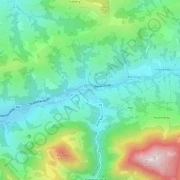
Name: Ybbsitz topographic map, elevation, terrain.
Location: Ybbsitz, Bezirk Amstetten, Lower Austria, 3341, Austria (47.92795 14.87520 47.96795 14.91520)
Average elevation: 598 m
Minimum elevation: 386 m
Maximum elevation: 1,109 m
Thank you for supporting this site ❤️
Make a donation
Make a donation
Gear up for your next adventure:
As an Amazon Associate, this site earns from qualifying purchases at no extra cost to you.