Geolocate

Kaytitinga I topographic map

Click on the map to display elevation.

About this map
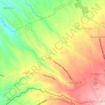
Name: Kaytitinga I topographic map, elevation, terrain.

Location: Kaytitinga I, Alfonso, Cavite, Calabarzon, 4123, Philippines (14.08757 120.80796 14.12757 120.84796)

Average elevation: 431 m

Minimum elevation: 313 m

Maximum elevation: 526 m

Other topographic maps

Click on a map to view its topography, its elevation and its terrain.
Amuyong

Philippines > Cavite > Alfonso

Average elevation: 543 m

Amuyong

Philippines > Cavite > Alfonso

Average elevation: 543 m

Gear up for your next adventure:

🔥Windproof Plasma Lighters - USB rechargeable lighters that work in high-altitude winds
🔦Headlamps - Hands-free lighting for hiking
🧭Global Orienteering Compass - High-precision liquid-filled compasses for accurate map reading and navigation
🧺Fast-Dry Microfiber Towels - Large towels that pack down to the size of an orange
🛠️Outdoor Repair Kits - Gear repair kits

As an Amazon Associate, this site earns from qualifying purchases at no extra cost to you.