Geolocate

Edzell topographic map

Click on the map to display elevation.

About this map

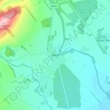
Name: Edzell topographic map, elevation, terrain.

Location: Edzell, Angus, Scotland, DD9 7TJ, United Kingdom (56.78999 -2.67585 56.82999 -2.63585)

Average elevation: 69 m

Minimum elevation: 34 m

Maximum elevation: 225 m

Other topographic maps

Click on a map to view its topography, its elevation and its terrain.

Glen Lethnot

United Kingdom > Scotland > Angus

Average elevation: 365 m

Loch Brandy

United Kingdom > Scotland > Angus

Average elevation: 691 m

Forfar

United Kingdom > Scotland > Angus

Average elevation: 95 m

Edzell Castle

United Kingdom > Scotland > Angus > Little Brechin

Average elevation: 98 m

Glamis Castle

United Kingdom > Scotland > Angus > Forfar > Deanbank

Average elevation: 69 m

Sand Martins

United Kingdom > Scotland > Angus > Forfar

Average elevation: 97 m

Glen Dye

United Kingdom > Scotland > Angus

Average elevation: 416 m

Forter Castle

United Kingdom > Scotland > Angus > Folda

Average elevation: 387 m

River North Esk

United Kingdom > Scotland > Angus

Average elevation: 204 m

River South Esk

United Kingdom > Scotland > Angus

Average elevation: 287 m

Glen Isla

United Kingdom > Scotland > Angus > Kirkton of Glenisla

Average elevation: 430 m

Glen Esk

United Kingdom > Scotland > Angus > Tarfside

Average elevation: 329 m

Glen Doll

United Kingdom > Scotland > Angus

Average elevation: 625 m

Loch Brandy

United Kingdom > Scotland > Angus

Average elevation: 691 m

Forter Castle

United Kingdom > Scotland > Angus > Folda

Average elevation: 387 m

Gear up for your next adventure:

🧺Fast-Dry Microfiber Towels - Large towels that pack down to the size of an orange
🛠️Outdoor Repair Kits - Gear repair kits
🥾Hiking Gaiters - Leg protection for trails
🎽Base Layers - Thermal base layers
🧦Merino Wool Hiking Socks - Moisture-wicking socks to prevent blisters during long topographic surveys

As an Amazon Associate, this site earns from qualifying purchases at no extra cost to you.