
Changsha topographic map
Click on the map to display elevation.
About this map
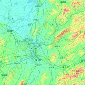
Name: Changsha topographic map, elevation, terrain.
Location: Changsha, Hunan, China (27.85121 111.89150 28.66442 114.25604)
Average elevation: 180 m
Minimum elevation: 19 m
Maximum elevation: 1,833 m
Other topographic maps
Click on a map to view its topography, its elevation and its terrain.
Langshan
China > Hunan > Xinning County > Xiabanshan
Langshan or Mount Lang (Chinese: 崀山) is a mountain and a scenic area in Xinning County, Hunan, China. It is described on the local signage as a "world famous UNESCO geopark of China" and was inscribed as part of the China Danxia World Heritage Site in 2010 because of its unique geological formations and…
Average elevation: 503 m