Geolocate

Naic topographic map

Click on the map to display elevation.

👉 Easily get elevation data in JSON, GeoTIFF and KML formats using Elevation API
Thank you for supporting this site ❤️
Make a donation

Gear up for your next adventure:

As an Amazon Associate, this site earns from qualifying purchases at no extra cost to you.

About this map

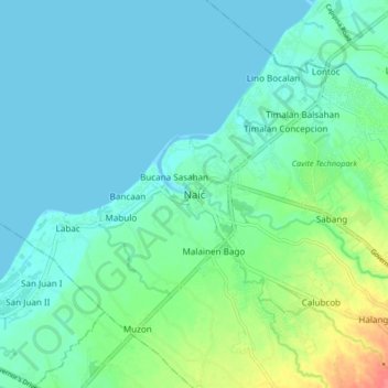
Name: Naic topographic map, elevation, terrain.

Location: Naic, Cavite, Calabarzon, 4110, Philippines (14.27939 120.72412 14.35939 120.80412)

Average elevation: 14 m

Minimum elevation: 0 m

Maximum elevation: 63 m

Gear up for your next adventure:

👕UPF 50+ Sun Shirts - Essential protection against the harsh Australian sun during field work
📱Shockproof Phone Cases - Extra protection for your smartphone against drops on rocky terrain
🧥Insulated Down Jackets - High warmth-to-weight ratio for cold nights in the high country
Altimeter Watches - Watches with altitude tracking
🪢Paracord - Multi-purpose survival cord

As an Amazon Associate, this site earns from qualifying purchases at no extra cost to you.