
Make a donation
Gear up for your next adventure:
As an Amazon Associate, this site earns from qualifying purchases at no extra cost to you.
Tilton topographic map
Click on the map to display elevation.
Make a donation
Gear up for your next adventure:
As an Amazon Associate, this site earns from qualifying purchases at no extra cost to you.
About this map
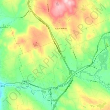
Name: Tilton topographic map, elevation, terrain.
Location: Tilton, Belknap County, New Hampshire, 03252, United States (43.43488 -71.62891 43.50224 -71.51075)
Average elevation: 196 m
Minimum elevation: 86 m
Maximum elevation: 356 m
Make a donation
Gear up for your next adventure:
As an Amazon Associate, this site earns from qualifying purchases at no extra cost to you.
Other topographic maps
Click on a map to view its topography, its elevation and its terrain.
Governors Island
United States > New Hampshire > Belknap County > Gilford > Dockham Shore
Average elevation: 162 m
Diamond Island
United States > New Hampshire > Belknap County > Gilford > Coleman Point
Average elevation: 154 m
Rattlesnake Island
United States > New Hampshire > Belknap County > Alton
Rattlesnake Island is about 2 miles (3 km) long, and approximately 5 miles (8 km) around its shore. The topography varies greatly. Some sections of the island are quite steep, with the land rising steeply from the shore (affording views of the area), while other sections, particularly on the "peninsula", which…
Average elevation: 159 m
Make a donation
Gear up for your next adventure:
As an Amazon Associate, this site earns from qualifying purchases at no extra cost to you.
Halfmoon Lake
United States > New Hampshire > Belknap County > Barnstead > Fernhill
Average elevation: 213 m
Make a donation
Gear up for your next adventure:
As an Amazon Associate, this site earns from qualifying purchases at no extra cost to you.
Make a donation
Gear up for your next adventure:
As an Amazon Associate, this site earns from qualifying purchases at no extra cost to you.
Sleepers Island
United States > New Hampshire > Belknap County > Alton > Smith Point
Average elevation: 163 m
Gilmanton Ironworks
United States > New Hampshire > Belknap County > Gilmanton
Average elevation: 224 m
Make a donation
Gear up for your next adventure:
As an Amazon Associate, this site earns from qualifying purchases at no extra cost to you.
Make a donation
Gear up for your next adventure:
As an Amazon Associate, this site earns from qualifying purchases at no extra cost to you.