
Make a donation
Gear up for your next adventure:
As an Amazon Associate, this site earns from qualifying purchases at no extra cost to you.
Sulzbach-Rosenberg topographic map
Click on the map to display elevation.
Make a donation
Gear up for your next adventure:
As an Amazon Associate, this site earns from qualifying purchases at no extra cost to you.
Sulzbach-Rosenberg
Das Klima vor Ort ist gemäßigt und relativ niederschlagsreich. Im langjährigen Mittel (1991–2020) fallen auf dem Gebiet von Sulzbach-Rosenberg ca. 800 mm Niederschlag im Jahresmittel, mit den höchsten Werten in den westlichen Teilen des Gemeindegebietes und den niedrigsten östlich von Rosenberg. Die Jahresmitteltemperatur liegt bei 8–9 °C (1991–2020), je nach Höhenlage.
Make a donation
Gear up for your next adventure:
As an Amazon Associate, this site earns from qualifying purchases at no extra cost to you.
About this map
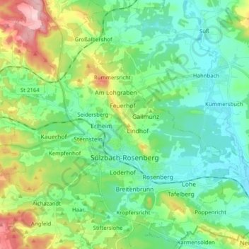
Name: Sulzbach-Rosenberg topographic map, elevation, terrain.
Average elevation: 439 m
Minimum elevation: 379 m
Maximum elevation: 590 m
Make a donation
Gear up for your next adventure:
As an Amazon Associate, this site earns from qualifying purchases at no extra cost to you.
Other topographic maps
Click on a map to view its topography, its elevation and its terrain.
Make a donation
Gear up for your next adventure:
As an Amazon Associate, this site earns from qualifying purchases at no extra cost to you.
Annaberg
Deutschland > Bayern > Landkreis Amberg-Sulzbach > Sulzbach-Rosenberg
Average elevation: 421 m
Make a donation
Gear up for your next adventure:
As an Amazon Associate, this site earns from qualifying purchases at no extra cost to you.
Trichenricht
Deutschland > Bayern > Landkreis Amberg-Sulzbach > Schnaittenbach
Average elevation: 498 m
Make a donation
Gear up for your next adventure:
As an Amazon Associate, this site earns from qualifying purchases at no extra cost to you.
Welluck
Deutschland > Bayern > Landkreis Amberg-Sulzbach > Auerbach in der Oberpfalz > Welluck
Average elevation: 465 m
Make a donation
Gear up for your next adventure:
As an Amazon Associate, this site earns from qualifying purchases at no extra cost to you.
Reichenbach
Deutschland > Bayern > Landkreis Amberg-Sulzbach > Auerbach in der Oberpfalz
Average elevation: 468 m
Make a donation
Gear up for your next adventure:
As an Amazon Associate, this site earns from qualifying purchases at no extra cost to you.
Degelsdorf
Deutschland > Bayern > Landkreis Amberg-Sulzbach > Auerbach in der Oberpfalz
Average elevation: 481 m
Neukirchen bei Sulzbach-Rosenberg
Deutschland > Bayern > Landkreis Amberg-Sulzbach
Average elevation: 496 m
Make a donation
Gear up for your next adventure:
As an Amazon Associate, this site earns from qualifying purchases at no extra cost to you.
Make a donation
Gear up for your next adventure:
As an Amazon Associate, this site earns from qualifying purchases at no extra cost to you.
Make a donation
Gear up for your next adventure:
As an Amazon Associate, this site earns from qualifying purchases at no extra cost to you.
Make a donation
Gear up for your next adventure:
As an Amazon Associate, this site earns from qualifying purchases at no extra cost to you.
Schönweiher
Deutschland > Bayern > Landkreis Amberg-Sulzbach > Sulzbach-Rosenberg > Forsthof
Average elevation: 467 m
Make a donation
Gear up for your next adventure:
As an Amazon Associate, this site earns from qualifying purchases at no extra cost to you.
Michelfeld
Deutschland > Bayern > Landkreis Amberg-Sulzbach > Auerbach in der Oberpfalz
Average elevation: 430 m
Make a donation
Gear up for your next adventure:
As an Amazon Associate, this site earns from qualifying purchases at no extra cost to you.
Make a donation
Gear up for your next adventure:
As an Amazon Associate, this site earns from qualifying purchases at no extra cost to you.
Siebeneichen
Deutschland > Bayern > Landkreis Amberg-Sulzbach > Sulzbach-Rosenberg
Average elevation: 425 m
Seidersberg
Deutschland > Bayern > Landkreis Amberg-Sulzbach > Sulzbach-Rosenberg
Average elevation: 439 m
Stadionberg
Deutschland > Bayern > Landkreis Amberg-Sulzbach > Hirschbach > Oberklausen
Average elevation: 478 m
Make a donation
Gear up for your next adventure:
As an Amazon Associate, this site earns from qualifying purchases at no extra cost to you.
Oberklausen
Deutschland > Bayern > Landkreis Amberg-Sulzbach > Hirschbach > Oberklausen
Average elevation: 479 m
Neuersdorf
Deutschland > Bayern > Landkreis Amberg-Sulzbach > Schnaittenbach > Neuersdorf
Average elevation: 445 m
Ransbach
Deutschland > Bayern > Landkreis Amberg-Sulzbach > Hohenburg > Ransbach
Average elevation: 463 m
Make a donation
Gear up for your next adventure:
As an Amazon Associate, this site earns from qualifying purchases at no extra cost to you.
Sackdilling
Deutschland > Bayern > Landkreis Amberg-Sulzbach > Auerbach in der Oberpfalz > Sackdilling
Average elevation: 490 m
Sand
Deutschland > Bayern > Landkreis Amberg-Sulzbach > Auerbach in der Oberpfalz
Average elevation: 454 m
Make a donation
Gear up for your next adventure:
As an Amazon Associate, this site earns from qualifying purchases at no extra cost to you.
Make a donation
Gear up for your next adventure:
As an Amazon Associate, this site earns from qualifying purchases at no extra cost to you.
Mertenberg
Deutschland > Bayern > Landkreis Amberg-Sulzbach > Kemnath am Buchberg
Average elevation: 540 m