
Make a donation
Gear up for your next adventure:
As an Amazon Associate, this site earns from qualifying purchases at no extra cost to you.
Gießen topographic map
Click on the map to display elevation.
Make a donation
Gear up for your next adventure:
As an Amazon Associate, this site earns from qualifying purchases at no extra cost to you.
Gießen
Nicht weit entfernt vom Stadttheater steht die Johanneskirche, die als größte evangelische Kirche Gießens in den Jahren 1891 bis 1893 nach Plänen des Berliner Architekten Hans Grisebach errichtet wurde. Der Turm der neo-romanischen Kirche überragt die umliegenden Gebäude mit einer Höhe von 75 Metern.
Make a donation
Gear up for your next adventure:
As an Amazon Associate, this site earns from qualifying purchases at no extra cost to you.
About this map
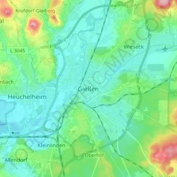
Name: Gießen topographic map, elevation, terrain.
Location: Gießen, Landkreis Gießen, Hessen, 35390, Deutschland (50.54621 8.63423 50.62621 8.71423)
Average elevation: 182 m
Minimum elevation: 150 m
Maximum elevation: 295 m
Make a donation
Gear up for your next adventure:
As an Amazon Associate, this site earns from qualifying purchases at no extra cost to you.
Other topographic maps
Click on a map to view its topography, its elevation and its terrain.