
Chaspuzac topographic map
Interactive map
Click on the map to display elevation.
About this map
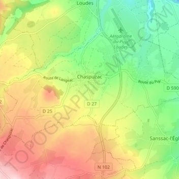
Name: Chaspuzac topographic map, elevation, terrain.
Average elevation: 886 m
Minimum elevation: 780 m
Maximum elevation: 1,013 m
Other topographic maps
Click on a map to view its topography, its elevation and its terrain.
Le Puy-en-Velay
Frankreich > Auvergne-Rhone-Alpen > Haute-Loire
Le Puy-en-Velay, Haute-Loire, Auvergne-Rhone-Alpen, Metropolitanes Frankreich, 43000, Frankreich
Average elevation: 737 m
Pont d'Estroulhas
Frankreich > Auvergne-Rhone-Alpen > Haute-Loire > Le Puy-en-Velay > Pont d'Estroulhas
Pont d'Estroulhas, Le Puy-en-Velay, Haute-Loire, Auvergne-Rhone-Alpen, Metropolitanes Frankreich, 43000, Frankreich
Average elevation: 696 m