
Panchase topographic map
Interactive map
Click on the map to display elevation.
About this map
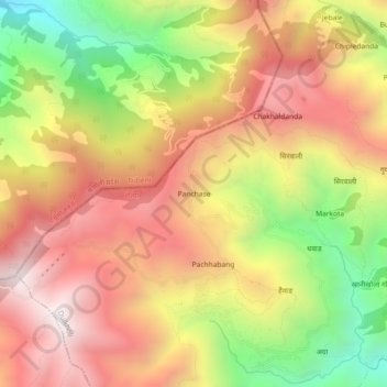
Name: Panchase topographic map, elevation, terrain.
Location: Panchase, दुईखोली-०४, Duikholi, रोल्पा, Lumbini, Népal (28.50988 82.46433 28.54988 82.50433)
Average elevation: 2,151 m
Minimum elevation: 1,449 m
Maximum elevation: 2,705 m
Other topographic maps
Click on a map to view its topography, its elevation and its terrain.
Jamli Pokara
Jamli Pokara, दुईखोली-०१, Duikholi, रोल्पा, Lumbini, Népal
Average elevation: 1,988 m