
Moniquirá topographic map
Interactive map
Click on the map to display elevation.
About this map
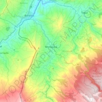
Name: Moniquirá topographic map, elevation, terrain.
Location: Moniquirá, Boyacá, Colombia (5.77715 -73.63163 5.95998 -73.46210)
Average elevation: 2,037 m
Minimum elevation: 1,476 m
Maximum elevation: 2,796 m
Other topographic maps
Click on a map to view its topography, its elevation and its terrain.
Isla Santa Ines
Colombia > Boyacá > Caserío Susaca
Isla Santa Ines, Caserío Susaca, Aquitania, Boyacá, Colombia
Average elevation: 3,019 m