
Whangarei topographic map
Interactive map
Click on the map to display elevation.
About this map
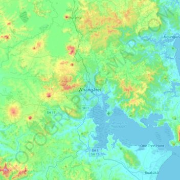
Name: Whangarei topographic map, elevation, terrain.
Average elevation: 96 m
Minimum elevation: 0 m
Maximum elevation: 500 m
Other topographic maps
Click on a map to view its topography, its elevation and its terrain.
Ōakura
New Zealand > Northland > Whangarei District
Ōakura, Whangārei District, Northland, 0184, New Zealand
Average elevation: 26 m
Tutukaka
New Zealand > Northland > Whangarei District
Tutukaka, Whangarei District, Northland, New Zealand, Philip Island
Average elevation: 18 m