
Libertytown topographic map
Interactive map
Click on the map to display elevation.
About this map
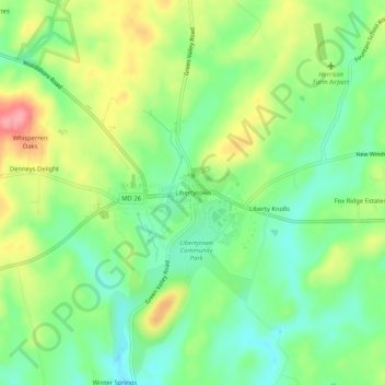
Name: Libertytown topographic map, elevation, terrain.
Average elevation: 161 m
Minimum elevation: 121 m
Maximum elevation: 222 m
Other topographic maps
Click on a map to view its topography, its elevation and its terrain.
Thurmont
United States > Maryland > Frederick County
Thurmont, Frederick County, Maryland, United States
Average elevation: 184 m
West Frederick Highlands
United States > Maryland > Frederick County > Ballenger Creek
West Frederick Highlands, Ballenger Creek, Frederick County, Maryland, 21703, United States
Average elevation: 113 m
Knoxville
United States > Maryland > Frederick County
Knoxville, Frederick County, Maryland, 41716, United States
Average elevation: 142 m
Myersville
United States > Maryland > Frederick County
Myersville, Frederick County, Maryland, United States
Average elevation: 199 m
Brunswick
United States > Maryland > Frederick County
Brunswick, Frederick County, Maryland, United States
Average elevation: 118 m
Middletown
United States > Maryland > Frederick County
Middletown, Frederick County, Maryland, 21769, United States
Average elevation: 165 m
Flint
United States > Maryland > Frederick County
Flint, Frederick County, Maryland, 21780, United States
Average elevation: 379 m
Clover Hill
United States > Maryland > Frederick County
Clover Hill, Frederick County, Maryland, 21702, United States
Average elevation: 111 m
Mount Airy Estates
United States > Maryland > Frederick County > Mount Airy Estates
Mount Airy Estates, Frederick County, Maryland, 21174, United States
Average elevation: 161 m
Wolfsville
United States > Maryland > Frederick County > Wolfsville
Wolfsville, Frederick County, Maryland, United States
Average elevation: 341 m
Colonial Heights
United States > Maryland > Frederick County > Thurmont > Colonial Heights
Colonial Heights, Thurmont, Frederick County, Maryland, 21788, United States
Average elevation: 157 m
Middle Creek
United States > Maryland > Frederick County > Valley Overlook
Middle Creek, Valley Overlook, Frederick County, Maryland, 21769, United States
Average elevation: 157 m
Sunday
United States > Maryland > Frederick County > Sunday
Sunday, Frederick County, Maryland, 21788, United States
Average elevation: 172 m
Frederick
United States > Maryland > Frederick County > Frederick
Frederick, Frederick County, Maryland, 21701-4546, United States
Average elevation: 165 m
Frederick
United States > Maryland > Frederick County
Frederick, Frederick County, Maryland, United States
Average elevation: 112 m