Bartoszyce County topographic map
Interactive map
Click on the map to display elevation.
About this map
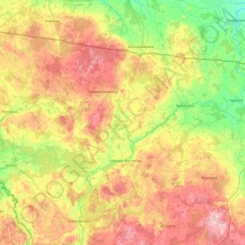
Name: Bartoszyce County topographic map, elevation, terrain.
Location: Bartoszyce County, Warmian-Masurian Voivodeship, Poland (54.02285 20.26099 54.40220 21.22055)
Average elevation: 98 m
Minimum elevation: 14 m
Maximum elevation: 213 m
Other topographic maps
Click on a map to view its topography, its elevation and its terrain.
Kętrzyn County
Poland > Warmian-Masurian Voivodeship
Kętrzyn County, Warmian-Masurian Voivodeship, Poland
Average elevation: 93 m
Elbląg County
Poland > Warmian-Masurian Voivodeship
Elbląg County, Warmian-Masurian Voivodeship, Poland
Average elevation: 55 m
Parys
Poland > Warmian-Masurian Voivodeship > Kętrzyn County > Parys
Parys, gmina Korsze, Kętrzyn County, Warmian-Masurian Voivodeship, Poland
Average elevation: 52 m
Kętrzyn
Poland > Warmian-Masurian Voivodeship > Kętrzyn County > Kętrzyn
Kętrzyn, Kętrzyn County, Warmian-Masurian Voivodeship, Poland
Average elevation: 101 m
Mrągowo County
Poland > Warmian-Masurian Voivodeship
Mrągowo County, Warmian-Masurian Voivodeship, Poland
Average elevation: 141 m
Mrągowo
Poland > Warmian-Masurian Voivodeship > Mrągowo
Mrągowo, powiat mrągowski, Warmian-Masurian Voivodeship, 11-700, Poland
Average elevation: 150 m
Olsztynek
Poland > Warmian-Masurian Voivodeship > Olsztynek
Olsztynek, gmina Olsztynek, powiat olsztyński, Warmian-Masurian Voivodeship, 11-015, Poland
Average elevation: 174 m
Reszel
Poland > Warmian-Masurian Voivodeship > Reszel
Reszel, gmina Reszel, powiat kętrzyński, Warmian-Masurian Voivodeship, Poland
Average elevation: 109 m