
Putre topographic map
Interactive map
Click on the map to display elevation.
About this map
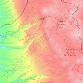
Name: Putre topographic map, elevation, terrain.
Average elevation: 3,263 m
Minimum elevation: 449 m
Maximum elevation: 6,299 m
Die Kleinstadt Putre ist einer der nördlichsten Orte Chiles. Sie liegt in der XV. Region (Región de Arica y Parinacota), rund 150 km östlich von der Küstenstadt Arica auf 3650 Metern Höhe und bildet den Eingang zum Nationalpark Lauca. Putre ist die Hauptstadt der Provinz Parinacota. Die Landschaft um Putre ist karg und gebirgig, die Einheimischen betreiben Landwirtschaft zur Eigenversorgung. Es gibt einige touristische Einrichtungen und einen Militärstützpunkt. Sehenswert ist die 1670 erbaute Kirche. Putre gehört seit dem Salpeterkrieg (1879–1883) zu Chile, vorher zu Peru.
Other topographic maps
Click on a map to view its topography, its elevation and its terrain.
Guallatiri
Chile > Región de Arica y Parinacota > Provincia de Parinacota > Putre
Guallatiri, Putre, Provincia de Parinacota, Región de Arica y Parinacota, Chile
Average elevation: 5,651 m