
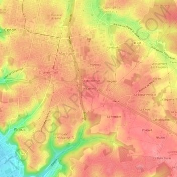
Le Canon topographic map
Interactive map
Click on the map to display elevation.
About this map
Name: Le Canon topographic map, elevation, terrain.
Average elevation: 62 m
Minimum elevation: 2 m
Maximum elevation: 86 m
Other topographic maps
Click on a map to view its topography, its elevation and its terrain.
Parc du Castel
France > Nouvelle-Aquitaine > Gironde > Floirac
Parc du Castel, La Souys, Floirac, Bordeaux, Gironde, Nouvelle-Aquitaine, France métropolitaine, 33270, France
Average elevation: 26 m
Parc du Rectorat
France > Nouvelle-Aquitaine > Gironde > Floirac
Parc du Rectorat, Dravemont, Floirac, Bordeaux, Gironde, Nouvelle-Aquitaine, France métropolitaine, 33270, France
Average elevation: 63 m
Cenon
France > Nouvelle-Aquitaine > Gironde > Floirac
Cenon, Floirac, Bordeaux, Gironde, Nouvelle-Aquitaine, France métropolitaine, 33270, France
Average elevation: 33 m