
Make a donation
Gear up for your next adventure:
As an Amazon Associate, this site earns from qualifying purchases at no extra cost to you.
Mount Kenya topographic map
Click on the map to display elevation.
Make a donation
Gear up for your next adventure:
As an Amazon Associate, this site earns from qualifying purchases at no extra cost to you.
Mount Kenya
The mountain's lower slopes, which have never been glaciated, are currently dominated by a mix of cultivation and forest, and are characterized by deep, fluvial V-shaped valleys with numerous branching tributaries. In contrast, the higher elevations of the moorland zone feature shallower, flat-bottomed U-shaped valleys carved by ancient glacial activity. This stark topographical shift marks the transition from landscapes shaped by millions of years of river erosion to those sculpted by the movement of prehistoric ice sheets.
Make a donation
Gear up for your next adventure:
As an Amazon Associate, this site earns from qualifying purchases at no extra cost to you.
About this map
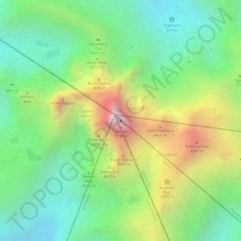
Name: Mount Kenya topographic map, elevation, terrain.
Location: Mount Kenya, Manyatta, Embu, Kenya (-0.15276 37.30916 -0.15266 37.30926)
Average elevation: 4,556 m
Minimum elevation: 4,181 m
Maximum elevation: 5,149 m
Make a donation
Gear up for your next adventure:
As an Amazon Associate, this site earns from qualifying purchases at no extra cost to you.
Other topographic maps
Click on a map to view its topography, its elevation and its terrain.
Embu
The Municipality of Embu has an elevation of 1,350 metres (4,429 ft), and is located on the foothills of Mount Kenya. It was the provincial headquarters of the defunct Eastern province, and is currently the Embu County Headquarters, hosting major public offices and institutions, including Embu Provincial…
Average elevation: 1,352 m