
Thank you for supporting this site ❤️
Make a donation
Make a donation
Gear up for your next adventure:
As an Amazon Associate, this site earns from qualifying purchases at no extra cost to you.
Kankabchén topographic map
Click on the map to display elevation.
Thank you for supporting this site ❤️
Make a donation
Make a donation
Gear up for your next adventure:
As an Amazon Associate, this site earns from qualifying purchases at no extra cost to you.
About this map
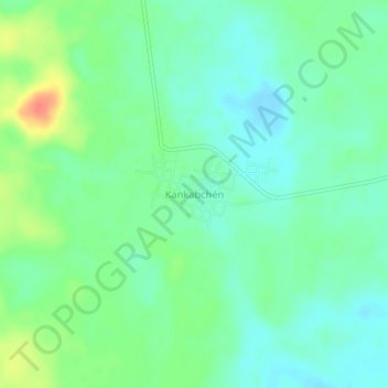
Name: Kankabchén topographic map, elevation, terrain.
Location: Kankabchén, José María Morelos, Quintana Roo, México (19.69426 -88.88279 19.73426 -88.84279)
Average elevation: 26 m
Minimum elevation: 10 m
Maximum elevation: 61 m
Thank you for supporting this site ❤️
Make a donation
Make a donation
Gear up for your next adventure:
As an Amazon Associate, this site earns from qualifying purchases at no extra cost to you.
Other topographic maps
Click on a map to view its topography, its elevation and its terrain.
Área de Protección de Flora y Fauna Bala'an K'aax
México > Quintana Roo > José María Morelos
Average elevation: 101 m