Geolocate

Vulcan topographic map

Click on the map to display elevation.

About this map

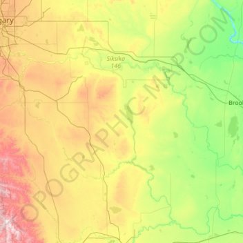
Name: Vulcan topographic map, elevation, terrain.

Location: Vulcan, Vulcan County, Alberta, Canada (49.75526 -113.65265 51.15526 -112.25265)

Average elevation: 931 m

Minimum elevation: 645 m

Maximum elevation: 1,800 m

Other topographic maps

Click on a map to view its topography, its elevation and its terrain.

McGregor Lake

Canada > Alberta > Vulcan County

Average elevation: 928 m

Village of Lomond

Canada > Alberta > Vulcan County

Average elevation: 874 m

Village of Lomond

Canada > Alberta > Vulcan County

Average elevation: 874 m

Gear up for your next adventure:

🛌Sleeping Mats - Insulated mats for camping comfort
🔦Headlamps - Hands-free lighting for hiking
🧢Wide Brim Sun Hats - Maximum coverage for the face and neck while out in the open
🪢550 Survival Paracord - Versatile cordage for gear repair and emergency lashing
🧯Animal Deterrent Spray - Safety spray for wildlife

As an Amazon Associate, this site earns from qualifying purchases at no extra cost to you.