
Parroquia Juan Rodríguez Suárez topographic map
Interactive map
Click on the map to display elevation.
About this map
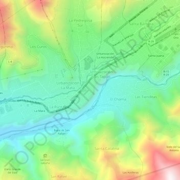
Name: Parroquia Juan Rodríguez Suárez topographic map, elevation, terrain.
Average elevation: 1,463 m
Minimum elevation: 1,068 m
Maximum elevation: 2,256 m
Other topographic maps
Click on a map to view its topography, its elevation and its terrain.
Mérida
Venezuela > Municipio Libertador
Mérida, Parroquia El Llano, Municipio Libertador, 5115, Venezuela
Average elevation: 2,660 m