
Make a donation
Gear up for your next adventure:
As an Amazon Associate, this site earns from qualifying purchases at no extra cost to you.
Wellsville topographic map
Click on the map to display elevation.
Make a donation
Gear up for your next adventure:
As an Amazon Associate, this site earns from qualifying purchases at no extra cost to you.
About this map
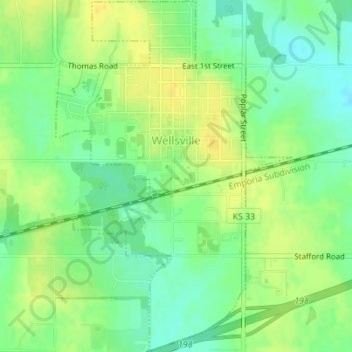
Name: Wellsville topographic map, elevation, terrain.
Location: Wellsville, Franklin County, Kansas, United States (38.70216 -95.09345 38.72901 -95.07026)
Average elevation: 317 m
Minimum elevation: 304 m
Maximum elevation: 327 m
Make a donation
Gear up for your next adventure:
As an Amazon Associate, this site earns from qualifying purchases at no extra cost to you.
Other topographic maps
Click on a map to view its topography, its elevation and its terrain.
Homewood
United States > Kansas > Franklin County
Homewood was located on the Atchison, Topeka and Santa Fe Railway at altitude 1,039 feet (317 m) above sea level. In 1900, it contained a population of about 100 inhabitants. Around this time, a number of stores operated out of the community, and it also had its own school. It was the supply and shipping point…
Average elevation: 320 m