
Make a donation
Gear up for your next adventure:
As an Amazon Associate, this site earns from qualifying purchases at no extra cost to you.
Edese Bos - Oost topographic map
Click on the map to display elevation.
Make a donation
Gear up for your next adventure:
As an Amazon Associate, this site earns from qualifying purchases at no extra cost to you.
About this map
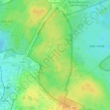
Name: Edese Bos - Oost topographic map, elevation, terrain.
Location: Edese Bos - Oost, Ede, Gelderland, Nederland, 6718 ZZ, Nederland (52.04379 5.67949 52.06379 5.69949)
Average elevation: 34 m
Minimum elevation: 20 m
Maximum elevation: 50 m
Make a donation
Gear up for your next adventure:
As an Amazon Associate, this site earns from qualifying purchases at no extra cost to you.
Other topographic maps
Click on a map to view its topography, its elevation and its terrain.
Sysselt
Nederland > Gelderland > Ede
De naam wordt ook geschreven als: (De) Sijsselt. Ook werd vroeger wel de naam: De Zijselt gebruikt (bijvoorbeeld op de topografische kaart 1847/8).
Average elevation: 35 m