
Community of Madrid topographic map
Interactive map
Click on the map to display elevation.
Community of Madrid
Most of province lies between 600 and 1,000 m above sea level. However, there the altitude ranges from the 2,428 metres of Peñalara and the 430 metres of the Alberche river when it leaves Villa del Prado into the province of Toledo. Other considerable heights, as well as being famous, are the Bola del Mundo ("Ball of the World") in Navacerrada, at a height of 2,258 m, the Siete Picos ("Seven Peaks") in Cercedilla, at 2,138 m, and the Peña Cebollera (2,129 m) at the northernmost end of the province, a tripoint between the Madrid region and the provinces of Segovia and Guadalajara.
About this map
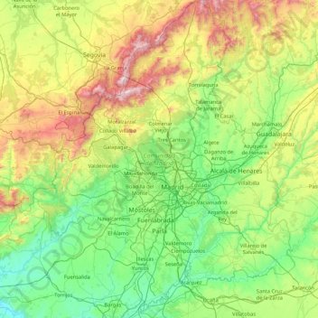
Name: Community of Madrid topographic map, elevation, terrain.
Location: Community of Madrid, Spain (39.88458 -4.57901 41.16574 -3.05299)
Average elevation: 852 m
Minimum elevation: 385 m
Maximum elevation: 2,404 m
Other topographic maps
Click on a map to view its topography, its elevation and its terrain.
Madrid
Spain > Community of Madrid > Área metropolitana de Madrid y Corredor del Henares > Madrid
Average elevation: 650 m