Geolocate

Tikhvin topographic map

Click on the map to display elevation.

About this map
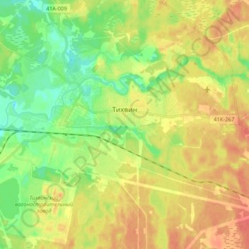
Name: Tikhvin topographic map, elevation, terrain.

Location: Tikhvin, Тихвинское городское поселение, Tihvinä District, Leningrad Oblast, Northwestern Federal District, Russia (59.59982 33.45022 59.67903 33.59639)

Average elevation: 54 m

Minimum elevation: 31 m

Maximum elevation: 76 m

Other topographic maps

Click on a map to view its topography, its elevation and its terrain.
Blacklake

Russia > Leningrad oblast > Tihvinä District

Average elevation: 139 m

Gear up for your next adventure:

🧥Thermal Emergency Blankets - Compact Mylar blankets to prevent hypothermia if stranded overnight
🛌Sleeping Bags - Sleeping bags for outdoor camping
🥾Heavy Duty Hiking Boots - Ankle-supporting boots for carrying heavy packs on steep contours
📖Australian Bush Survival Books - Local knowledge on finding water and surviving the outback
📡Satellite Messengers - Emergency communication devices

As an Amazon Associate, this site earns from qualifying purchases at no extra cost to you.