
Briton Ferry topographic map
Interactive map
Click on the map to display elevation.
About this map
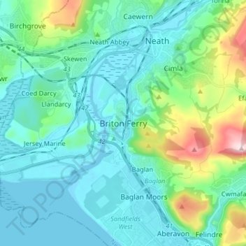
Name: Briton Ferry topographic map, elevation, terrain.
Average elevation: 69 m
Minimum elevation: -4 m
Maximum elevation: 370 m
Other topographic maps
Click on a map to view its topography, its elevation and its terrain.
Warren Hill
United Kingdom > Wales > Neath Port Talbot > Briton Ferry
Warren Hill, Briton Ferry, Neath Port Talbot, Wales, SA11, United Kingdom
Average elevation: 30 m
Blaengwynfi
United Kingdom > Wales > Neath Port Talbot > Blaengwynfi
Blaengwynfi, Neath Port Talbot, Wales, SA13 3TB, United Kingdom
Average elevation: 412 m
Glyn-neath
United Kingdom > Wales > Neath Port Talbot
Glyn-neath, Neath Port Talbot, Wales, SA11 5AY, United Kingdom
Average elevation: 253 m
Port Talbot
United Kingdom > Wales > Neath Port Talbot
Port Talbot, Neath Port Talbot, Wales, SA13 1LY, United Kingdom
Average elevation: 76 m