Geolocate

Ashtabula topographic map

Click on the map to display elevation.

About this map
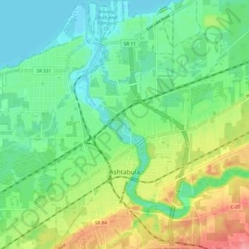
Name: Ashtabula topographic map, elevation, terrain.

Location: Ashtabula, Ashtabula Township, Ashtabula County, Ohio, 44004, United States (41.84358 -80.83720 41.91178 -80.76721)

Average elevation: 202 m

Minimum elevation: 171 m

Maximum elevation: 263 m

Other topographic maps

Click on a map to view its topography, its elevation and its terrain.
Pierpont

United States > Ohio > Ashtabula County

Average elevation: 305 m

Chapel

United States > Ohio > Ashtabula County

Average elevation: 258 m

Phelps Creek

United States > Ohio > Ashtabula County

Average elevation: 326 m

Pierpont

United States > Ohio > Ashtabula County

Average elevation: 305 m

Gear up for your next adventure:

🛰️Handheld GPS Units - Rugged GPS devices for tracking coordinates and elevation in the Australian bush
🧯Animal Deterrent Spray - Safety spray for wildlife
📡Satellite Messengers - Emergency communication devices
🐍Snake Gaiters - Protection against snake bites
🛠️Outdoor Repair Kits - Gear repair kits

As an Amazon Associate, this site earns from qualifying purchases at no extra cost to you.