Geolocate

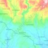
Lucena topographic map

Click on the map to display elevation.

About this map

Name: Lucena topographic map, elevation, terrain.

Location: Lucena, Prosperidad, Agusan del Sur, Caraga, 8500, Philippines (8.54682 125.85325 8.58682 125.89325)

Average elevation: 36 m

Minimum elevation: 27 m

Maximum elevation: 47 m

Other topographic maps

Click on a map to view its topography, its elevation and its terrain.
Maug River

Philippines > Agusan del Sur > Prosperidad

Average elevation: 221 m

Gear up for your next adventure:

🎒40L Day Hiking Backpacks - Comfortable packs with hydration support for long days exploring topographic peaks
📍Handheld GPS - GPS devices for hiking and navigation
🔌Fast Charging Adapters - Quickly top up all your gear before heading back into the field
🧤Thermal Hiking Gloves - Keep your hands warm and functional during high-altitude winter treks
🛌Sleeping Bags - Sleeping bags for outdoor camping

As an Amazon Associate, this site earns from qualifying purchases at no extra cost to you.