
Make a donation
Gear up for your next adventure:
As an Amazon Associate, this site earns from qualifying purchases at no extra cost to you.
Großostheim topographic map
Click on the map to display elevation.
Make a donation
Gear up for your next adventure:
As an Amazon Associate, this site earns from qualifying purchases at no extra cost to you.
About this map
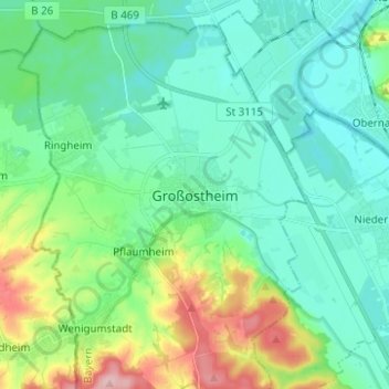
Name: Großostheim topographic map, elevation, terrain.
Location: Großostheim, Landkreis Aschaffenburg, Bavaria, 63762, Germany (49.88075 9.03559 49.96075 9.11559)
Average elevation: 148 m
Minimum elevation: 108 m
Maximum elevation: 270 m
Make a donation
Gear up for your next adventure:
As an Amazon Associate, this site earns from qualifying purchases at no extra cost to you.
Other topographic maps
Click on a map to view its topography, its elevation and its terrain.
Make a donation
Gear up for your next adventure:
As an Amazon Associate, this site earns from qualifying purchases at no extra cost to you.
Weisserstein
Germany > Bavaria > Landkreis Aschaffenburg > Rothenbucher Forst
Average elevation: 429 m