
Fareham topographic map
Interactive map
Click on the map to display elevation.
About this map
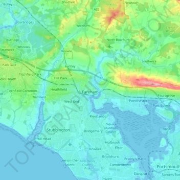
Name: Fareham topographic map, elevation, terrain.
Location: Fareham, Hampshire, England, United Kingdom (50.80894 -1.31291 50.89901 -1.11229)
Average elevation: 21 m
Minimum elevation: -4 m
Maximum elevation: 128 m
Other topographic maps
Click on a map to view its topography, its elevation and its terrain.
Cow Down
United Kingdom > England > Hampshire > Test Valley
Cow Down, Test Valley, Hampshire, England, SP11 9HE, United Kingdom
Average elevation: 193 m
Basingstoke
United Kingdom > England > Hampshire > Basingstoke and Deane
Basingstoke, Basingstoke and Deane, Hampshire, England, United Kingdom
Average elevation: 110 m
Chandler's Ford
United Kingdom > England > Hampshire
Chandler's Ford, Eastleigh, Hampshire, England, United Kingdom
Average elevation: 39 m
North Street
United Kingdom > England > Hampshire > East Hampshire > Ropley > North Street
North Street, Ropley, East Hampshire, Hampshire, England, SO24 0DF, United Kingdom
Average elevation: 143 m