Geolocate

Ciputri topographic map

Click on the map to display elevation.

About this map
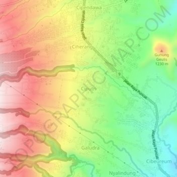
Name: Ciputri topographic map, elevation, terrain.

Location: Ciputri, Cianjur, West Java, Indonesia (-6.78884 107.02807 -6.74884 107.06807)

Average elevation: 1,119 m

Minimum elevation: 862 m

Maximum elevation: 1,388 m

Other topographic maps

Click on a map to view its topography, its elevation and its terrain.

Sindangbarang

Indonesia > West Java > Cianjur

Average elevation: 148 m

Wangunjaya

Indonesia > West Java > Cianjur

Average elevation: 17 m

Kertamukti

Indonesia > West Java > Cianjur

Average elevation: 25 m

Alun Alun Suryakancana

Indonesia > West Java > Cianjur

Average elevation: 2,568 m

Gear up for your next adventure:

🔥Windproof Plasma Lighters - USB rechargeable lighters that work in high-altitude winds
⌛Survival Blankets - Emergency thermal blankets
🎧Bluetooth Outdoor Earbuds - Listen to navigation cues or podcasts during long solo treks
🪢550 Survival Paracord - Versatile cordage for gear repair and emergency lashing
🧼Biodegradable Outdoor Soap - Clean gear and yourself without harming the local ecosystem

As an Amazon Associate, this site earns from qualifying purchases at no extra cost to you.