
Buwagga topographic map
Interactive map
Click on the map to display elevation.
About this map
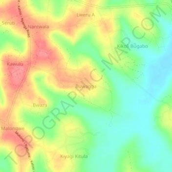
Name: Buwagga topographic map, elevation, terrain.
Location: Buwagga, Buikwe, Central Region, Uganda (0.29553 33.02382 0.33553 33.06382)
Average elevation: 1,226 m
Minimum elevation: 1,189 m
Maximum elevation: 1,266 m
Other topographic maps
Click on a map to view its topography, its elevation and its terrain.