Geolocate

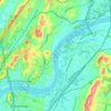
Valley Village topographic map

Click on the map to display elevation.

About this map

Name: Valley Village topographic map, elevation, terrain.

Location: Valley Village, Chattanooga, Hamilton County, East Tennessee, Tennessee, 00003, United States (35.03063 -85.37413 35.07063 -85.33413)

Average elevation: 260 m

Minimum elevation: 189 m

Maximum elevation: 565 m

Other topographic maps

Click on a map to view its topography, its elevation and its terrain.
Gear up for your next adventure:

🛌Compact Down Sleeping Bags - Warmth without the bulk, ideal for backcountry camping
🎽Base Layers - Thermal base layers
🧼Biodegradable Outdoor Soap - Clean gear and yourself without harming the local ecosystem
📟Satellite Messengers - Two-way satellite communication to stay in touch beyond the cellular grid
🦶Orthotic Hiking Insoles - Extra arch support for long-distance topographic treks

As an Amazon Associate, this site earns from qualifying purchases at no extra cost to you.