
Pine Valley Mountain Wilderness topographic map
Interactive map
Click on the map to display elevation.
About this map
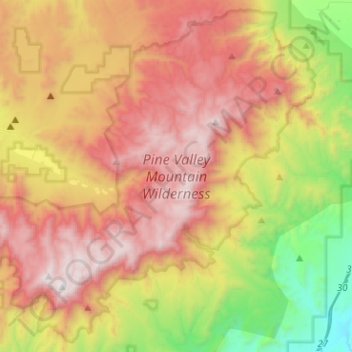
Name: Pine Valley Mountain Wilderness topographic map, elevation, terrain.
Average elevation: 2,125 m
Minimum elevation: 1,117 m
Maximum elevation: 3,147 m
Pine Valley Mountain Wilderness is a 50,232-acre (203.28 km2) wilderness area located in the Dixie National Forest in the U.S. state of Utah. It is the fourth-largest wilderness area located entirely within the state (following the High Uintas Wilderness, Zion Wilderness, and Cedar Mountain Wilderness). The wilderness designation protects the Pine Valley Mountain range, a large rock outcrop surrounded by desert. The Pine Valley Mountains form the Pine Valley Laccolith, one of the largest laccoliths in the United States. Elevations in the wilderness range from 6,000 feet (1,800 m) to 10,365 feet (3,159 m) at the summit of Signal Peak.
Other topographic maps
Click on a map to view its topography, its elevation and its terrain.
Springdale
United States > Utah > Washington County
Springdale, Washington County, Utah, 84767, United States
Average elevation: 1,354 m
Saint George
United States > Utah > Washington County
Saint George, Washington County, Utah, United States
Average elevation: 929 m
Cottonwood Canyon Wilderness
United States > Utah > Washington County > Washington
Cottonwood Canyon Wilderness, Washington, Washington County, Utah, United States
Average elevation: 1,213 m
Toquerville
United States > Utah > Washington County
Toquerville, Washington County, Utah, 84774, United States
Average elevation: 1,301 m
Hurricane
United States > Utah > Washington County
Hurricane, Washington County, Utah, United States
Average elevation: 1,154 m
Ivins
United States > Utah > Washington County > Ivins
Ivins, Washington County, Utah, 84738, United States
Average elevation: 1,007 m
Zion National Park
United States > Utah > Washington County
Zion National Park, Washington County, Utah, United States
Average elevation: 1,877 m