
Liddes topographic map
Interactive map
Click on the map to display elevation.
About this map
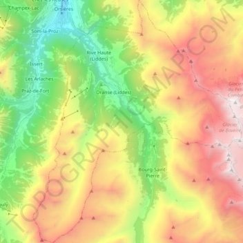
Name: Liddes topographic map, elevation, terrain.
Location: Liddes, Entremont, Wallis, 1945, Schweiz (45.91392 7.12342 46.03428 7.27199)
Average elevation: 2,123 m
Minimum elevation: 875 m
Maximum elevation: 3,665 m
Die Gemeinde liegt an der Hauptstrasse 21 zum Grossen Sankt Bernhard als zweitletztes Dorf vor der Passhöhe. Sie grenzt im Norden an Orsières, im Osten an Val de Bagnes und im Süden an Bourg-Saint-Pierre und besteht neben Liddes-Ville aus den Weilern Chandonne, Dranse, Rive-Haute, Fontaine-Dessous, Fontaine-Dessus, Les Moulins, Vichères, Fornex, Chez-Petit und Palasuit.
Other topographic maps
Click on a map to view its topography, its elevation and its terrain.
Le Catogne
Schweiz > Wallis > Entremont > Sembrancher
Le Catogne, Sembrancher, Entremont, Wallis, 2303, Schweiz
Average elevation: 1,949 m
Bourg-Saint-Pierre
Bourg-Saint-Pierre, Entremont, Wallis, 1946, Schweiz
Average elevation: 2,530 m
Champex-Lac
Champex-Lac, Orsières, Entremont, Wallis, 2303, Schweiz
Average elevation: 1,552 m