
Ait Ouaarda topographic map
Interactive map
Click on the map to display elevation.
About this map
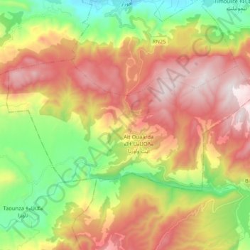
Name: Ait Ouaarda topographic map, elevation, terrain.
Average elevation: 1,062 m
Minimum elevation: 476 m
Maximum elevation: 1,708 m
Other topographic maps
Click on a map to view its topography, its elevation and its terrain.
Afourer
Maroc > cercle d'Afourar > Timoulilt
Afourer, Timoulilt, caïdat d'Afourar, cercle d'Afourar, Province d'Azilal, Béni Mellal-Khénifra, 22702, Maroc
Average elevation: 526 m
Afourar
Afourar, caïdat d'Afourar, cercle d'Afourar, Province d'Azilal, Béni Mellal-Khénifra, 22052, Maroc
Average elevation: 900 m