Geolocate

Upperco topographic map

Click on the map to display elevation.

About this map

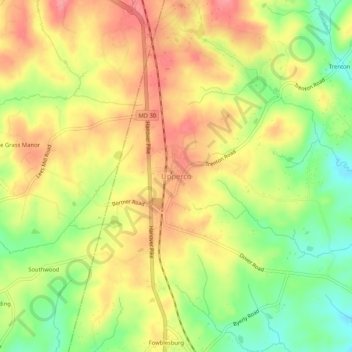
Name: Upperco topographic map, elevation, terrain.

Location: Upperco, Baltimore County, Maryland, 21155, United States (39.54292 -76.85598 39.58292 -76.81598)

Average elevation: 218 m

Minimum elevation: 169 m

Maximum elevation: 258 m

Other topographic maps

Click on a map to view its topography, its elevation and its terrain.

Treetops

United States > Maryland > Baltimore County

Average elevation: 131 m

Towson

United States > Maryland > Baltimore County > Towson

Average elevation: 114 m

Dundalk

United States > Maryland > Baltimore County > Dundalk

Average elevation: 6 m

Rosedale

United States > Maryland > Baltimore County > Rosedale

Average elevation: 28 m

Gear up for your next adventure:

🎒40L Day Hiking Backpacks - Comfortable packs with hydration support for long days exploring topographic peaks
🚴Cycling Backpacks - Backpacks for cyclists
📣High-Decibel Survival Whistles - Signaling tool for rescue that carries much further than a human voice
📸Action Cameras - Record your journey across interesting topographic features in 4K
Outdoor Coffee Makers - Enjoy quality coffee at the summit of your favorite peak

As an Amazon Associate, this site earns from qualifying purchases at no extra cost to you.