
Make a donation
Gear up for your next adventure:
As an Amazon Associate, this site earns from qualifying purchases at no extra cost to you.
Southfield topographic map
Click on the map to display elevation.
Make a donation
Gear up for your next adventure:
As an Amazon Associate, this site earns from qualifying purchases at no extra cost to you.
About this map
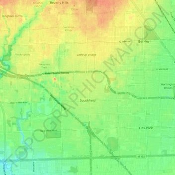
Name: Southfield topographic map, elevation, terrain.
Location: Southfield, Oakland County, Michigan, United States (42.44203 -83.31994 42.51747 -83.20052)
Average elevation: 210 m
Minimum elevation: 189 m
Maximum elevation: 232 m
Make a donation
Gear up for your next adventure:
As an Amazon Associate, this site earns from qualifying purchases at no extra cost to you.
Other topographic maps
Click on a map to view its topography, its elevation and its terrain.
Make a donation
Gear up for your next adventure:
As an Amazon Associate, this site earns from qualifying purchases at no extra cost to you.
Carpenter Lake Nature Preserve
United States > Michigan > Oakland County > Southfield
Average elevation: 207 m
Dollar Lake
United States > Michigan > Oakland County > Independence Charter Township
Average elevation: 306 m
Make a donation
Gear up for your next adventure:
As an Amazon Associate, this site earns from qualifying purchases at no extra cost to you.
Cranberry Lake
United States > Michigan > Oakland County > White Lake Charter Township
Average elevation: 295 m
Oxbow
United States > Michigan > Oakland County > White Lake Charter Township
Average elevation: 293 m
Make a donation
Gear up for your next adventure:
As an Amazon Associate, this site earns from qualifying purchases at no extra cost to you.
North Farmington
United States > Michigan > Oakland County > Farmington Hills
Average elevation: 277 m
Make a donation
Gear up for your next adventure:
As an Amazon Associate, this site earns from qualifying purchases at no extra cost to you.
Union Lake
United States > Michigan > Oakland County > White Lake Charter Township
Average elevation: 290 m
Huron Heights
United States > Michigan > Oakland County > Waterford Charter Township
Average elevation: 292 m
Davisburg
United States > Michigan > Oakland County > Springfield Charter Township
Average elevation: 309 m
Make a donation
Gear up for your next adventure:
As an Amazon Associate, this site earns from qualifying purchases at no extra cost to you.
Rochester Hills
United States > Michigan > Oakland County > Rochester Hills
Rochester Hills is bordered to the north by Oakland Charter Township along Dutton Road, to the south by the city of Troy along South Boulevard, to the east by Shelby Township in Macomb County along Dequindre Road, and to the west by the city of Auburn Hills along part of Adams Road. Rochester Hills is also…
Average elevation: 246 m