
Salina topographic map
Interactive map
Click on the map to display elevation.
About this map
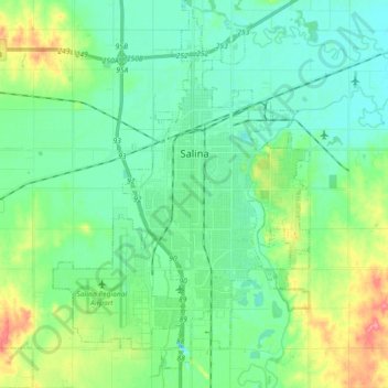
Name: Salina topographic map, elevation, terrain.
Location: Salina, Saline County, Kansas, 67401, États-Unis d'Amérique (38.75464 -97.70599 38.89597 -97.55762)
Average elevation: 383 m
Minimum elevation: 362 m
Maximum elevation: 442 m
Other topographic maps
Click on a map to view its topography, its elevation and its terrain.
Salina
États-Unis d'Amérique > Kansas > Saline County > Salina > Salina
Salina, Saline County, Kansas, 67401, États-Unis d'Amérique
Average elevation: 390 m