
Make a donation
Gear up for your next adventure:
As an Amazon Associate, this site earns from qualifying purchases at no extra cost to you.
Missinipe topographic map
Click on the map to display elevation.
Make a donation
Gear up for your next adventure:
As an Amazon Associate, this site earns from qualifying purchases at no extra cost to you.
About this map
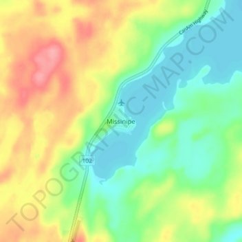
Name: Missinipe topographic map, elevation, terrain.
Location: Missinipe, Division No. 18, Saskatchewan, Canada (55.58164 -104.79090 55.62164 -104.75090)
Average elevation: 380 m
Minimum elevation: 344 m
Maximum elevation: 431 m
Make a donation
Gear up for your next adventure:
As an Amazon Associate, this site earns from qualifying purchases at no extra cost to you.
Other topographic maps
Click on a map to view its topography, its elevation and its terrain.
Lac la Plonge
Canada > Saskatchewan > Division No. 18 > Unorganized Division No. 18
Average elevation: 466 m
Make a donation
Gear up for your next adventure:
As an Amazon Associate, this site earns from qualifying purchases at no extra cost to you.