
Currahee Mountain topographic map
Interactive map
Click on the map to display elevation.
About this map
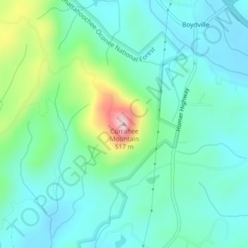
Name: Currahee Mountain topographic map, elevation, terrain.
Location: Currahee Mountain, Stephens County, Georgia, United States (34.52922 -83.37577 34.52932 -83.37567)
Average elevation: 303 m
Minimum elevation: 239 m
Maximum elevation: 518 m
Other topographic maps
Click on a map to view its topography, its elevation and its terrain.
Toccoa
United States > Georgia > Stephens County > Toccoa > Toccoa
Toccoa, Stephens County, Georgia, 30577, United States
Average elevation: 299 m