
Emigrant topographic map
Interactive map
Click on the map to display elevation.
About this map
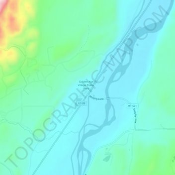
Name: Emigrant topographic map, elevation, terrain.
Location: Emigrant, Park County, Montana, 59027, United States (45.35021 -110.75355 45.39021 -110.71355)
Average elevation: 1,530 m
Minimum elevation: 1,470 m
Maximum elevation: 1,801 m
Other topographic maps
Click on a map to view its topography, its elevation and its terrain.
Sugar Loaf Mountain
United States > Montana > Park County
Sugar Loaf Mountain, Park County, Montana, United States
Average elevation: 2,343 m
Livingston
United States > Montana > Park County
Livingston, Park County, Montana, United States
Average elevation: 1,421 m
Electric
United States > Montana > Park County > Electric
Electric, Park County, Montana, 59030, United States
Average elevation: 1,776 m