
Success topographic map
Interactive map
Click on the map to display elevation.
About this map
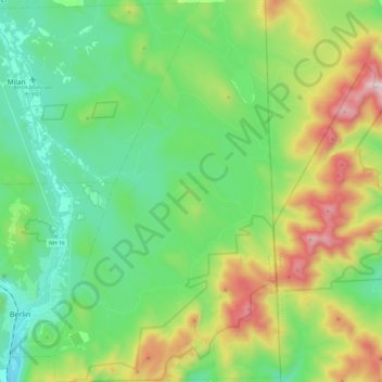
Name: Success topographic map, elevation, terrain.
Location: Success, Coos County, New Hampshire, United States (44.43819 -71.16202 44.61030 -71.01878)
Average elevation: 565 m
Minimum elevation: 259 m
Maximum elevation: 1,259 m
The highest point in the township is the summit of Mount Success, with an elevation of 3,565 feet (1,087 m) above sea level, in the southeast part of the township along the crest of the Mahoosucs. The Appalachian Trail follows the Mahoosuc crest across the township.
Other topographic maps
Click on a map to view its topography, its elevation and its terrain.
Errol
United States > New Hampshire > Coos County
Errol, Coös County, New Hampshire, United States
Average elevation: 453 m
Holden Hill
United States > New Hampshire > Coos County > Stewartstown
Holden Hill, Stewartstown, Coös County, New Hampshire, United States
Average elevation: 660 m
Upper Village
United States > New Hampshire > Coos County > Gorham
Upper Village, Gorham, Coös County, New Hampshire, 03581, United States
Average elevation: 343 m
Lombard Pond
United States > New Hampshire > Coos County > Colebrook
Lombard Pond, Colebrook, Coos County, New Hampshire, United States
Average elevation: 402 m
Mount Martha
United States > New Hampshire > Coos County > Carroll
Mount Martha, Carroll, Coös County, New Hampshire, United States
Average elevation: 823 m