
Make a donation
Gear up for your next adventure:
As an Amazon Associate, this site earns from qualifying purchases at no extra cost to you.
Alandroal topographic map
Click on the map to display elevation.
Make a donation
Gear up for your next adventure:
As an Amazon Associate, this site earns from qualifying purchases at no extra cost to you.
Alandroal
Alandroal es una villa portuguesa perteneciente al distrito de Évora, región de Alentejo y comunidad intermunicipal de Alentejo Central, con cerca de 1900 habitantes. Se ubica a 341 m de altitud sobre el mar.
Make a donation
Gear up for your next adventure:
As an Amazon Associate, this site earns from qualifying purchases at no extra cost to you.
About this map
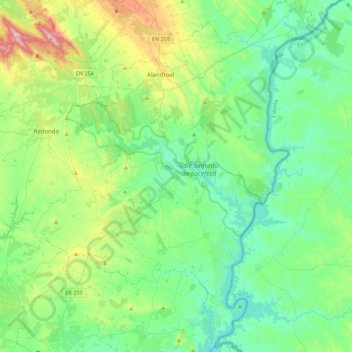
Name: Alandroal topographic map, elevation, terrain.
Location: Alandroal, Évora, Portugal (38.43011 -7.56367 38.77407 -7.20371)
Average elevation: 236 m
Minimum elevation: 111 m
Maximum elevation: 646 m
Make a donation
Gear up for your next adventure:
As an Amazon Associate, this site earns from qualifying purchases at no extra cost to you.