
Make a donation
Gear up for your next adventure:
As an Amazon Associate, this site earns from qualifying purchases at no extra cost to you.
Fredart Lake topographic map
Click on the map to display elevation.
Make a donation
Gear up for your next adventure:
As an Amazon Associate, this site earns from qualifying purchases at no extra cost to you.
About this map
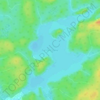
Name: Fredart Lake topographic map, elevation, terrain.
Average elevation: 409 m
Minimum elevation: 399 m
Maximum elevation: 430 m
Make a donation
Gear up for your next adventure:
As an Amazon Associate, this site earns from qualifying purchases at no extra cost to you.
Other topographic maps
Click on a map to view its topography, its elevation and its terrain.
Burditt Lake
Canada > Ontario > Kenora District > Unorganized Kenora District
Average elevation: 367 m
Make a donation
Gear up for your next adventure:
As an Amazon Associate, this site earns from qualifying purchases at no extra cost to you.
Cardinal (Lac) Lake
Canada > Ontario > Kenora District > Unorganized Kenora District
Average elevation: 392 m
Hudson Bay Lowlands
Canada > Ontario > Kenora District > Unorganized Kenora District
Average elevation: 17 m
Make a donation
Gear up for your next adventure:
As an Amazon Associate, this site earns from qualifying purchases at no extra cost to you.
Carroll Lake
Canada > Ontario > Kenora District > Unorganized Kenora District
Average elevation: 338 m
Granite Lake
Canada > Ontario > Kenora District > Unorganized Kenora District
Average elevation: 355 m
Make a donation
Gear up for your next adventure:
As an Amazon Associate, this site earns from qualifying purchases at no extra cost to you.
Gordon Island
Canada > Ontario > Kenora District > Unorganized Kenora District
Average elevation: 349 m
Make a donation
Gear up for your next adventure:
As an Amazon Associate, this site earns from qualifying purchases at no extra cost to you.
Grindstone Lake
Canada > Ontario > Kenora District > Unorganized Kenora District
Average elevation: 371 m
Make a donation
Gear up for your next adventure:
As an Amazon Associate, this site earns from qualifying purchases at no extra cost to you.
Warwick Lake
Canada > Ontario > Kenora District > Unorganized Kenora District
Average elevation: 341 m
Slate Islands
Canada > Ontario > Kenora District > Unorganized Kenora District
Average elevation: 322 m
Make a donation
Gear up for your next adventure:
As an Amazon Associate, this site earns from qualifying purchases at no extra cost to you.
Mackey Island
Canada > Ontario > Kenora District > Unorganized Kenora District
Average elevation: 336 m
Big Island Lake
Canada > Ontario > Kenora District > Unorganized Kenora District
Average elevation: 430 m
Make a donation
Gear up for your next adventure:
As an Amazon Associate, this site earns from qualifying purchases at no extra cost to you.
Nine Mile Lake
Canada > Ontario > Kenora District > Unorganized Kenora District
Average elevation: 413 m
Make a donation
Gear up for your next adventure:
As an Amazon Associate, this site earns from qualifying purchases at no extra cost to you.
Chisholm Island
Canada > Ontario > Kenora District > Unorganized Kenora District
Average elevation: 323 m
Clearwater Bay
Canada > Ontario > Kenora District > Unorganized Kenora District
Average elevation: 334 m
Make a donation
Gear up for your next adventure:
As an Amazon Associate, this site earns from qualifying purchases at no extra cost to you.
Muskeg River
Canada > Ontario > Kenora District > Unorganized Kenora District
Average elevation: 357 m
Muskeg River
Canada > Ontario > Kenora District > Unorganized Kenora District
Average elevation: 363 m
Dingwall Island
Canada > Ontario > Kenora District > Unorganized Kenora District
Average elevation: 325 m
Make a donation
Gear up for your next adventure:
As an Amazon Associate, this site earns from qualifying purchases at no extra cost to you.
Little Boulder Lake
Canada > Ontario > Kenora District > Unorganized Kenora District
Average elevation: 359 m
Cameron Island
Canada > Ontario > Kenora District > Unorganized Kenora District
Average elevation: 338 m
Make a donation
Gear up for your next adventure:
As an Amazon Associate, this site earns from qualifying purchases at no extra cost to you.