Geolocate

Three Forks topographic map

Click on the map to display elevation.

About this map
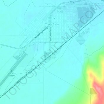
Name: Three Forks topographic map, elevation, terrain.

Location: Three Forks, Gallatin County, Montana, 59752, United States (45.86781 -111.58054 45.90006 -111.53467)

Average elevation: 1,249 m

Minimum elevation: 1,236 m

Maximum elevation: 1,327 m

Other topographic maps

Click on a map to view its topography, its elevation and its terrain.
Town Center

United States > Montana > Gallatin County > Big Sky

Average elevation: 1,952 m

Mount Hebgen

United States > Montana > Gallatin County

Average elevation: 2,378 m

Gallatin Gateway

United States > Montana > Gallatin County

Gallatin Gateway is a census-designated place (CDP) in Gallatin County, Montana, United States. As of the 2020 census, Gallatin Gateway had a population of 967. Elevation is 4,953 ft (1,510 m).

Average elevation: 1,519 m
Bozeman Beacon

United States > Montana > Gallatin County

Average elevation: 1,583 m

Burke Park

United States > Montana > Gallatin County > Bozeman

Average elevation: 1,494 m

Clarkston

United States > Montana > Gallatin County

Average elevation: 1,236 m

Logan

United States > Montana > Gallatin County

Average elevation: 1,294 m

Chestnut

United States > Montana > Gallatin County

Average elevation: 1,752 m

Gear up for your next adventure:

🚗Car Camping Gear - Equipment for vehicle camping
🧊Insulated Cooler Bags - Keep food fresh for day trips to remote geographic sites
🪢Paracord - Multi-purpose survival cord
🐍Australian Snake Bite Kits - Specific pressure immobilization bandages for Australian venomous snakes
🧭Global Orienteering Compass - High-precision liquid-filled compasses for accurate map reading and navigation

As an Amazon Associate, this site earns from qualifying purchases at no extra cost to you.