
Make a donation
Gear up for your next adventure:
As an Amazon Associate, this site earns from qualifying purchases at no extra cost to you.
Salento topographic map
Click on the map to display elevation.
Make a donation
Gear up for your next adventure:
As an Amazon Associate, this site earns from qualifying purchases at no extra cost to you.
About this map
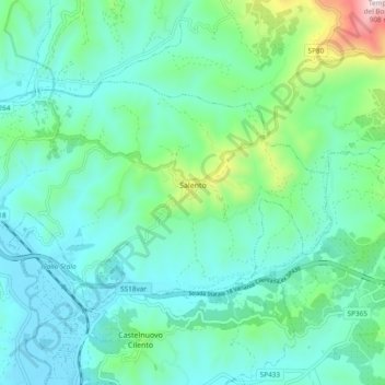
Name: Salento topographic map, elevation, terrain.
Location: Salento, Salerno, Campania, Italy (40.22627 15.12956 40.26804 15.22425)
Average elevation: 178 m
Minimum elevation: 8 m
Maximum elevation: 881 m
Make a donation
Gear up for your next adventure:
As an Amazon Associate, this site earns from qualifying purchases at no extra cost to you.
Other topographic maps
Click on a map to view its topography, its elevation and its terrain.
Make a donation
Gear up for your next adventure:
As an Amazon Associate, this site earns from qualifying purchases at no extra cost to you.
Make a donation
Gear up for your next adventure:
As an Amazon Associate, this site earns from qualifying purchases at no extra cost to you.
Pontecagnano Faiano
Italy > Campania > Salerno > Pontecagnano Faiano > Pontecagnano Faiano
Average elevation: 79 m