Geolocate

Bangon topographic map

Click on the map to display elevation.

About this map

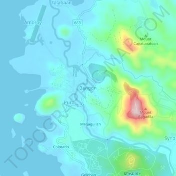
Name: Bangon topographic map, elevation, terrain.

Location: Bangon, Aroroy, Masbate, Bicol Region, Philippines (12.46803 123.36654 12.50803 123.40654)

Average elevation: 45 m

Minimum elevation: -2 m

Maximum elevation: 311 m

Gear up for your next adventure:

🔭Compact Hiking Binoculars - Lightweight optics for scouting routes or birdwatching
🪑Portable Backpacking Chairs - A comfortable seat for studying maps at the end of the day
🧢Outdoor Sun Hats - Sun protection hats for hiking
🌿Flora and Fauna Field Guides - Identify the plants and animals you encounter on your route
🧥Thermal Emergency Blankets - Compact Mylar blankets to prevent hypothermia if stranded overnight

As an Amazon Associate, this site earns from qualifying purchases at no extra cost to you.