
Make a donation
Gear up for your next adventure:
As an Amazon Associate, this site earns from qualifying purchases at no extra cost to you.
Wollmerschied topographic map
Click on the map to display elevation.
Make a donation
Gear up for your next adventure:
As an Amazon Associate, this site earns from qualifying purchases at no extra cost to you.
Wollmerschied
Wollmerschied ist ein Stadtteil der 12 km entfernt gelegenen Kernstadt Lorch im südhessischen Rheingau. Für die ehemals selbständige Gemeinde Wollmerschied besteht ein eigener Ortsbezirk mit Ortsbeirat. Der auf fast 400 Metern Höhe gelegene Ort liegt in unmittelbarer Nähe zum Rheinsteig.
Make a donation
Gear up for your next adventure:
As an Amazon Associate, this site earns from qualifying purchases at no extra cost to you.
About this map
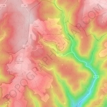
Name: Wollmerschied topographic map, elevation, terrain.
Location: Wollmerschied, Rheingau-Taunus-Kreis, Hessen, Deutschland (50.09087 7.84593 50.12851 7.88443)
Average elevation: 374 m
Minimum elevation: 175 m
Maximum elevation: 457 m
Make a donation
Gear up for your next adventure:
As an Amazon Associate, this site earns from qualifying purchases at no extra cost to you.