Geolocate

Mayamot topographic map

Click on the map to display elevation.

About this map

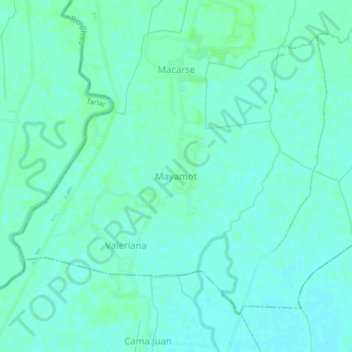
Name: Mayamot topographic map, elevation, terrain.

Location: Mayamot, Zaragoza, Nueva Ecija, Central Luzon, Philippines (15.39082 120.75218 15.43082 120.79218)

Average elevation: 16 m

Minimum elevation: 12 m

Maximum elevation: 20 m

Gear up for your next adventure:

☀️Portable Solar Chargers - High-efficiency panels to hang on your backpack while walking
🧊Insulated Stainless Steel Flasks - Keep water cold for 24 hours in the heat or coffee hot in the cold
📡Satellite Messengers - Emergency communication devices
🎒Daypacks - Compact backpacks for short hikes
📍Handheld GPS - GPS devices for hiking and navigation

As an Amazon Associate, this site earns from qualifying purchases at no extra cost to you.