
Make a donation
Gear up for your next adventure:
As an Amazon Associate, this site earns from qualifying purchases at no extra cost to you.
Mayne topographic map
Click on the map to display elevation.
Make a donation
Gear up for your next adventure:
As an Amazon Associate, this site earns from qualifying purchases at no extra cost to you.
About this map
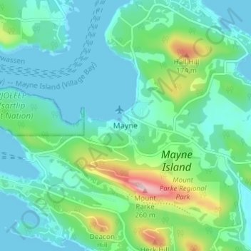
Name: Mayne topographic map, elevation, terrain.
Average elevation: 52 m
Minimum elevation: 0 m
Maximum elevation: 241 m
Make a donation
Gear up for your next adventure:
As an Amazon Associate, this site earns from qualifying purchases at no extra cost to you.
Other topographic maps
Click on a map to view its topography, its elevation and its terrain.
North Pender Island
Canada > British Columbia > Capital Regional District > Southern Gulf Islands Electoral Area
Average elevation: 23 m
Galiano Island
Canada > British Columbia > Capital Regional District > Southern Gulf Islands Electoral Area
Average elevation: 24 m
Gulf Islands National Park Reserve
Canada > British Columbia > Capital Regional District > Southern Gulf Islands Electoral Area
Average elevation: 57 m
Saturna Island
Canada > British Columbia > Capital Regional District > Southern Gulf Islands Electoral Area
Average elevation: 34 m
Make a donation
Gear up for your next adventure:
As an Amazon Associate, this site earns from qualifying purchases at no extra cost to you.
Portland Island
Canada > British Columbia > Capital Regional District > Southern Gulf Islands Electoral Area
Average elevation: 7 m
Mayne Island
Canada > British Columbia > Capital Regional District > Southern Gulf Islands Electoral Area > Mayne
Average elevation: 26 m
James Island
Canada > British Columbia > Capital Regional District > Southern Gulf Islands Electoral Area
James Island, one of British Columbia's Gulf Islands, lies in Haro Strait between Sidney Island and the coast of Vancouver Island near Sidney, British Columbia. James Island is approximately 2.4 km (1.5 mi) from the coast of Vancouver Island, and 145 km (90 mi) from Seattle, Washington. James Island has an…
Average elevation: 8 m
Piers Island
Canada > British Columbia > Capital Regional District > Southern Gulf Islands Electoral Area
Average elevation: 4 m
Make a donation
Gear up for your next adventure:
As an Amazon Associate, this site earns from qualifying purchases at no extra cost to you.
Buck Lake
Canada > British Columbia > Capital Regional District > Southern Gulf Islands Electoral Area
Average elevation: 58 m
Pym Island
Canada > British Columbia > Capital Regional District > Southern Gulf Islands Electoral Area
Average elevation: 2 m
Haro Strait
Canada > British Columbia > Capital Regional District > Southern Gulf Islands Electoral Area
Average elevation: 24 m
North Pender Island
Canada > British Columbia > Capital Regional District > Southern Gulf Islands Electoral Area
Average elevation: 23 m
Make a donation
Gear up for your next adventure:
As an Amazon Associate, this site earns from qualifying purchases at no extra cost to you.
Sidney Island
Canada > British Columbia > Capital Regional District > Southern Gulf Islands Electoral Area
Sidney Island is one of the southern Gulf Islands located between the southwest coast of British Columbia, Canada and Vancouver Island, BC, near James Island. Sidney Island has an elevation of 77 metres (252 feet 8 inches) above mean sea level at its highest point. It is located across Sidney Channel, just…
Average elevation: 7 m
Mayne Island
Canada > British Columbia > Capital Regional District > Southern Gulf Islands Electoral Area > Mayne
Average elevation: 26 m